
Monday, February 18, 2013
Wolverine Cirque
So, a little catch up is in order. Needless to say I am still adding to my consecutive months of skiing in the Wasatch mountains. I am now at 29 months. Since my last post I have skied 16 times in the backcountry and 7 times at a resort. I have been able to ski the Park City Mountain Resort and Deer Valley for the first time too. I quite enjoyed my skiing experience at PCMR and DV.
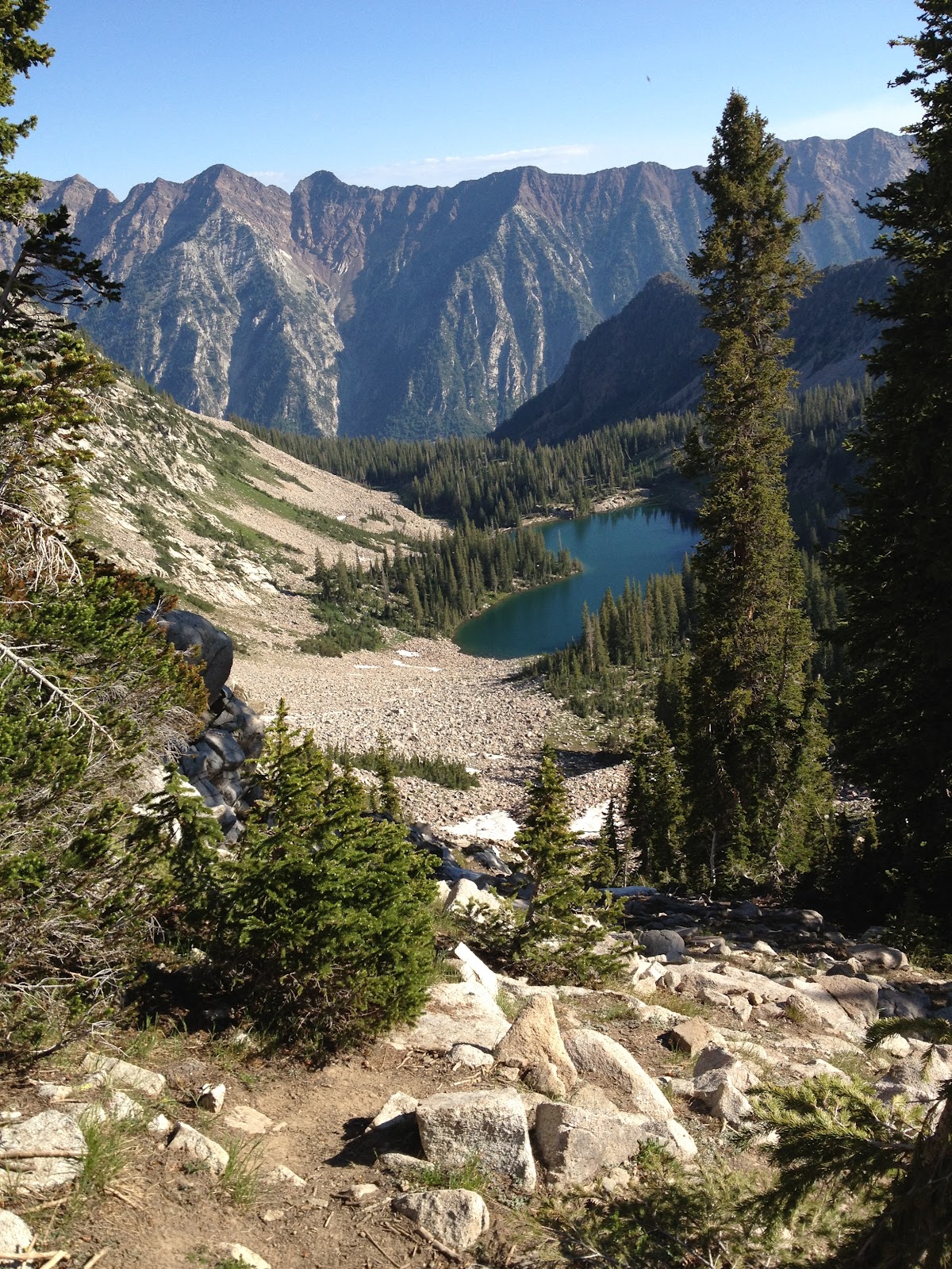
Craig had mentioned that he wanted to get out on a backcountry outing a couple of weeks back. We had initially planned to hike into the Coalpit headwall for some steep skiing. Harrison, our spiritual guide had hiked in there Sunday and the snow was too thin for any decent skiing. He guided Craig and I to the Wolverine Cirque just east of the Alta ski resort. We started hiking when the sun came up. At the Twin Lakes pass I noticed some coyote tracks in the snow. We followed the coyote tracks to the top of Patsey Marley where we transitioned. We skied along the rim of the cirque to the Huge Chute. The coyote tracks were right there on fresh windblown snow at the edge of the cornice. Harrison tested the cornice, found it stable and dropped into the chute. The Huge Chute is rated S4- and one star by Andrew McLean. It is wide chute with exposure on the skiers right about half way down. Harrison suggested that we practice our jump turns to practice for steeper and tighter chutes. The Huge Chute is a steady 40 degrees and about 500 feet of vertical to the apron. We each took our turn, skied out the apron to a transition spot and skinned back up to the top of Patsey Marley. On the second lap we saw a few more skiers. We transitioned and skied the rim again but this time to the Tips and Tails Chute. Along the way we stopped at the Bombay Chute for a look. Tips and Tails was a little more narrow and longer to the apron. It is rated S4 and one star. Another fun bit of steep skiing and a nice apron. We skinned back up to Patsey Marley and then skied the northeast face, through the trees and back to the car. A great morning of skiing given the poor snow conditions we currently have. Hopefully the storm that starts this Wednesday will bring lots of freshies.
Saturday, October 27, 2012
Skiing and Canyoneering
To say that I live a unique state with lots of contrast is a huge understatement. Here is an example of some of the contrasts this state has to offer recreationists. On Friday I had an appointment with a customer in Mountain Green a small community near the Odgen mountains (north end of the Wasatch). My client's home was only 10 or so miles from Snowbasin ski resort which just got the majority of the precipitation that the last storm brought through. Because of the temperature drop with this storm Snowbasin had about 30 inches of new snow. After my appointment I drove up to the lodge and hiked up the mountain to get excellent powder turns. I have 25 months of consecutive skiing in the Wasatch mountains. This was my official start to the 2012-2013 ski season.

 Early Saturday morning (really still night) I got up and met Bill and a couple other hikers just off I-15. We loaded into Bill's Exploader and headed south. I-15 to Hwy 6 south to I-70 west to Hwy 24 south to Hanksville. At Hanksville we refueled, went potty and bought convenience store food and drink. We continued further south on the Scenic Byway Hwy 95. A few miles out of Hanksville we turned off on an unmarked gravel road heading west. We snaked alone this road that is in the Poison Springs area for about 4 or 5 miles till we came to a few vehicles with tents nearby. We unloaded here, talked to the two souls that were awake and getting geared up. We quickly geared up too and headed for our first canyon. We were looking for the opening into Constrychnine. We hiked up and down over the rolling terrain looking for a GPS waypoint that would be the start of the adventure. The opening to this canyon was a huge surprise. All of a sudden we were upon a gaping hole in the earth. There was some webbing wrapped around some rocks signaling this as the first rappel of a little over 100 feet. Once down in the canyon I was delighted with the beautiful smooth sandstone rock walls. We hiked along to the next rappel a bit longer at almost 200 feet. The bottom of the canyon was open for easy hiking with a few obstacles along the way. The next rappel was into a dark hole. After hiking through some narrow, high walls the canyon opened up. What done already? We followed the GPS waypoints for the long climbing hike back to the car.


After a drive south to a road side picnic area we had our lunch and rested a bit before driving back north to our next canyon the Leprechaun. This canyon was different in a lot of ways but the first difference was that we had the long climbing hike to get to the head of the canyon. Leprechaun Canyon has three branches. We were headed for the start of the West Leprechaun Canyon. It was like hiking in Snow Canyon in St. George area in that we were hiking over and around sandstone hills. After our first short 60 foot rappel I quickly learned why we had brought knee and elbow pads. We used them to add to our leverage as we down climbed short obstacles and got into increasingly narrow slots. We used shorter ropes to down climb along our route. One of the narrow wall sections lasted for about 100 yards but I may be exaggerating a bit. That section took the longest to negotiate for me being a newbie and all. When we exited the narrow canyon we were in a beautiful creek bed with high walls. We had an easy walk back to the car. One of the hikers in our party had completely worn out the rear section of his pants. Mine were in pretty rough shape too. We changed into comfortable cloths and drove back to Hanksville for burgers, fries and shakes. Then the long drive home.


Saturday, October 20, 2012
Lone Peak
When I look east from my front porch I look directly at Lone Peak. It rises almost 7,000 vertical feet from my front porch to the peak. I have become somewhat fixated on it over that previous year since I watched this video. http://youtu.be/TwYIbafCEnc One summer Saturday night after I got the honeydos done I hiked up the Bear Creek trail toward the summit. I was treated to the most beautiful sunset over the Great Salt Lake and the Oquirrh Mountains. Continuing up I could see into Utah County. I saw some fireworks in Utah County as it got dark. I turned around and headed down but got a good taste of what would be in store for an assault on the peak. The trail was loose and steep. Actually was easier going up than going down. So when Connie went to Disneyland with the Hunts I had a Saturday to myself. I started up the Jacobs Ladder trail early and hiked in the dark with a headlight for about 20 minutes before the sun started to lighten my way. Turns out it was the opening day of deer hunting season. As I ascended I past abandoned 4 wheelers and I could start to pick out orange jacketed hunters perched over the side of the lower mountain. Also as it got light guns started to fire. At one point I observed a hunter taking aim and firing. I could also see his target - a deer. It took a couple of shots but I think he got it. I didn't wait to see, I kept hiking. Eventually I came to the Draper Ridge trail junction. The trail was not as steep at this point making for very pleasurable hiking. The terrain also changed to a more alpine environment. Eventually I came to the upper cirque. It is loaded with large granite boulders. I thought I was following the main trail but ended up scrambling over these big boulders in an inefficient way. Once I got to the end of the upper cirque I started to ascend to the final ridge to the peak. I met 3 hiker at this point a Dad and two adult daughters. The Dad had summitted Lone Peak an astounding 29 times. Both daughters had also summitted before. I joined their group and followed them to the summit. The Dad's trail knowledge made the final scramble easy and fun. This summit is absolutely incredible. Getting to it is one thing but actually standing on it is something else. It's like standing on your kitchen table with dangerous drops on all sides. And the view is the best - in all directions. I was starting to chill so I didn't stay long on the summit. I stayed with the daddy daughter group all the way down. Turns out there is a better route up through the cirque. By staying higher on the west side of the cirque there was a pretty smooth trail back to the alpine meadow area. Then the fun begins. The steep decent on slippery trails made for slower going than I anticipated. Trekking poles helped but only somewhat. Our little group took a few breaks on the way down including our lunch break in the upper cirque. The Dad and daughters were such good and nice people. It was a real pleasure hiking with them. I had thoughts of bolting ahead but didn't. I was pretty worn out at this point but mostly I enjoyed their company. We said our goodbyes at the trailhead and I drove on home total exhausted. About 10 hours of hiking. The only picture I got was the picture of me on the summit. The rest are from the internet. I’ll check my batteries before my next hike up to the summit of Lone Peak. Yes I want to do it again.


Saturday, September 1, 2012
Mount Timpanogos revisited
I convinced a couple of co-workers to join me for an overnight hike up Mt. Timpanogos. Scott, Sam and I meet at the Aspen Grove trailhead at about 2:30 and were hiking before 3. This was my first time hiking Timp via the Aspen Grove trail. The Primroase Cirque is a wonderfully beautiful backdrop for a hike. As I looked up the cirque at the trailhead I thought there was no way there is a trail up that thing. The trail zigzags up however and provides numerous viewpoints and spectacular waterfalls. Once we crested the Primroase Cirque we started looking for a campsite. We found a nice place a stone’s throw off the trail near Hidden Lake. There was a herd of mountain goats grazing on the west facing slope just above our campsite. They are awesome to behold. Scott was kind enough to pack in my binoculars so we got a good close-up view of them. After we set up camp I strapped my skis on my empty backpack and hiked up to Emerald Lake with my peeps in tow. I put on my crampons at Emerald Lake and hiked up the lower section of the snow field until there was a break in the snow. I should have hiked higher for steeper angles but my legs were pretty squishy from carrying skis and camping gear up that much vertical. I called it sufficient for my August turns. We hiked back down to our campsite and tried to enjoy our freeze-dried meal. The blueberry cheesecake pouch was a big hit. We filled our water bottles and headed to bed.
The night was something else. We could hear what seemed like a steady stream of hikers going up and down the trail. Some were singing. We also experience a heck of a light show with a lighting storm that rolled through in the wee hours of the morning. Our plan was to get up at 5am and head for the summit. It was still pretty nasty weather so we just enjoyed the comfort of our tents and sleeping bags. We laid there wondering what had become of all the hikers we heard walk past us throughout the night. We found out later in the day that at one point there was over 60 people crammed in the quonset hut at Emerald Lake. I'm sure glad we stayed in our tents.
After I heated water for my oatmeal I ran out of gas for the stove so Sam and Scott were stuck with granola bars and other dry foods for breakfast. I felt pretty guilty for not bringing a full canister of gas or at least heating water for someone else first. I packed up my skis and boots, water and snacks and we headed up toward the summit. It was about 8:30am. I stashed my skis, boots and backpack at the quonset and we headed for the saddle. From the quonset we could see the saddle but the summit was under a cloud. I was surprised to see so few people. At the saddle the wind and cold hit us hard. We were prepared for the weather and added another layer. Just as we got to the saddle the sky cleared and we could see some blue sky. At one point we could see the summit hut too. We thought we had timed it perfectly to have clear views from the summit however after about half way up the to the summit from the saddle the clouds had come back. A solo trail runner passed us on the way up and a couple of hikers passed us on their way down. When we arrived at the summit only the solo runner was there. He said it took him two and half hours to summit from the Aspen Grove trailhead. Pretty impressive. He looked real cold sitting there and headed down. We didn't stay long as there was no view but we were there all alone. We passed a few more hikers going up as we were descending. Near the saddle I came face to face with a mountain goat. Before I could get my camera out though he had walked over behind some rocks. I was able to snag a quick video of him before he disappeared in the fog. From the saddle back to the quonset we ran into more hikers heading for the summit. Many though were not dressed appropriately for the cool, damp weather. While our hiking experience was that of pleasure they were probably suffering.
Back at the quonset I was please to see my skis were still there so I did a September 1st repeat of last night's ski. Scott got video evidence. I NOW HAVE 24 MONTHS OF CONSECUTIVE SKIING IN THE WASATCH MOUNTAINS. We dashed back down the trail to our campsite to pack up and pack out. We were lucky to have a space of weather where we could pack up without rain. Our gear was still wet from the wet weather. Once we started down the rain picked up. It rained on us most of the way out. The waterfalls were even more beautiful. Just before the trailhead the sun peeped out for a few minutes and dried our pants a little. Put another Timp summit on the list for Sam and I. For Scott it was his virgin Timp excursion.


Saturday, July 7, 2012
Gunsight Chute
Morning hike started at Alta. Hiked under the Sunnyside lift, crossed the creek and up toward the Greeley bowl. At the base of the bowl I looked down as a large bull moose crossed the open space below me and disappeared into the scrub. Headed south to the base of the Gunsight chute. Just before the snow I looked up on the Greeley side hill and saw a deer watching me. Not much snow but I was already there with skis so what the heck. At the snow I put on my crampons and hiked up the snow. I transitioned to skis and got about 25 turns on the way down. On the hike out I saw another deer bounding across the trail. I now have 22 months of consecutive skiing in the Wasatch mountains.


Tuesday, July 3, 2012
Pfeifferhorn
Got to the White Pine trailhead at 7:00am. Not too many cars in the lot. Headed up the White Pine trail to the Red Pine cut off. At the White Pine bridge there was a powerful flow of water. I continue up the Red Pine trail past the Maybird cutoff to the north end of Beautiful Red Pine lake. There was a group of older teenaged boys admiring the view. I hiked on past them to the south end of the lake and the schoolbus sized rock. I followed a faint trail up to a boulder field. I stopped at the boulders to enjoy a Ding Dong. It was nothing to enjoy. Way beyond it's "best before" date. My solitude was broken by a group of 3 trail runners on their way down. I scrambled up over the rocks to the rocky ridgeline. The ridgeline provided excellent views of the whole Red Pine drainage. there are 3 more small lakes above the main Red Pine lake. I followed the carons along the ridge west to a trail. The trail leads to another rock/boulder ridge. This was tricky navigating along this section but I never felt exposed. From there a final trail to the steep climb up to the summit. I arrived on top at a little before 10am. I was the only one up there (well, me and the mountain goats). I enjoyed the 360 degree view and identified as many of the peaks as I could before tightening my laces and starting down. Back to the knife edge I meet the teenagers on their way up. They asked if the approach was steep. As I was scrambling down from the ridge I began to run into small groups and single hikers on their way up. When I got back to the Red Pine lake there were skads of people. Many were fishing. I picked up the pace hoping to get our before noon. I continued to pass folks on their way in. I got back to the trailhead at about 12:30pm. I ate my pb&j on the way to the office.


This video is best viewed at the youtube site - change the quality setting to HD
While I was still at my office, one of my co-workers called and asked if I had started a fire while I was in the mountains.


This video is best viewed at the youtube site - change the quality setting to HD
While I was still at my office, one of my co-workers called and asked if I had started a fire while I was in the mountains.

Saturday, June 23, 2012
2012 - MS 150 Bicycle Ride
Scott picked me up at the office at 4ish on Friday afternoon. We fought rush hour and construction traffic all the way to the Logan fairgrounds. Rich showed up shortly after we got there. After we set up camp and picked up our registration packets we all hopped in Rich's car to get dinner. We went to the Firehouse Pizza and Pasta place on the south end of town. Scott said his pasta what the best ever. My favorite part was the warm chocolate chip cookie with ice cream. Back at our campsite we wandered around the fairgrounds after dinner for a while and chatted up with a few people that we knew. Brett Young showed up and camped with us. I was ready for bed by 9:30ish. I woke up before 6 to tinkle and then went back to my sleeping bag until after 6. I grabbed some breakfast and then got geared up to ride. Scott, Rich, Brett and I worked our way to the start line and got out on with the first wave of riders. We were still weaving around riders a bit when a fast moving train of Cisco riders blew by. Scott and I tried to tag on but their pace was smoking hot. We were able to find other riders to tag onto most of the way out but kept loosing them to the rest stops. We were buzzing along nicely when another fast train of riders blew past. I think one of them was my neighbor Dennis. I hollered but but he was busy gritting his teeth. Scott and I had a stratagem to ride to the 50-60 mile point before our first break. This first half of the ride was so beautiful and nice with no noticeable wind. Rural Cache Valley is really a spectacular place to ride a bike. As we were heading west to our first rest stop in Weston, Idaho the wind started to kick up and we could feel the heat of the day. We made a pretty fast stop and then had a tailwind for the next 5 or so miles until the course turned south and our face was right into a brisk, hot wind. Our pace slowed from about 22mph to about 15mph. A group of 4 Autoliv cyclists passed us going about 20 so we hopped on. We followed them all the way to the lunch stop. I was pretty hungry for my 10:30am sandwich. Scott and I choked down our food and went to the bikes. We debated whether to go or wait for the riders we had just followed. We elected to leave thinking that they would pass us soon and we could tag on again. No such luck. We rode the last 30 miles alone taking turns with our noses in the wind. We didn't realize until after we finished that no one passed us. We, on the other hand, passed a bunch of riders on this last stretch. As we rode by Scott's grandpa's homestead I got a short Cache Valley history lesson. Scott was emotional and teared up. My eyes were too hot and dry to tear so I just kept pedalling. We saw riders sagging with less than 10 miles to go (really). We finished strong keeping our pace between 15mph and 20mph. We enjoyed the enthusiasm of the finish area. It was 12:30, a half an hour off our goal finish time.We showered, cleaned up our camp area and headed for McDonalds. I got a large milkshake and Scott got a large smoothie. Fast minivan ride home. Scott said "well, there is another MS ride in the books."
Me with the finish line cheerleaders - I have the Dave Zabriskie hair thing going on

Me with the finish line cheerleaders - I have the Dave Zabriskie hair thing going on

Subscribe to:
Posts (Atom)